
He said scientists have noticed a trend of very deep cloud systems developing over the southeast Arabian Sea, and added that sometimes, these systems intrude into the land, like in 2019.

The intensity of rainfall is likely to increase with the likelihood of very heavy falls at a few places and extremely heavy falls at isolated places on May 15, reports Sanjeeb Mukherjee.

This would be the second cyclonic storm in the Arabian Sea this year.

It will also be the third cyclone to hit the western state in June since 1965, the meteorological office said.

As the Northeast monsoon intensified across Tamil Nadu, the regional weather office issued heavy rainfall alert to a number of districts. Chief Minister M K Stalin reviewed the situation and directed precautionary measures.

A depression over the southeast Arabian Sea, south of Porbandar in Gujarat, is likely to move northwestward and intensify into a cyclonic storm, the India Meteorological Department said on Tuesday.

Cyclone 'Biparjoy' has an extensive damaging potential and it is likely to impact Kutch, Devbhoomi Dwarka and Jamnagar districts of Gujarat the most, the India meteorological department said on Tuesday.

vThe longest duration cyclone over the north Indian Ocean had developed over the Bay of Bengal and weakened over the Arabian Sea between November 8-23, 1977 with a life period of 14 days and six hours.

Conditions were becoming favourable for further advance of the southwest monsoon over some more parts of the south peninsula and east India and adjoining areas between June 18 and 21.

An IMD bulletin said the low pressure area could intensify into a cyclonic storm, triggering heavy to very heavy rainfall in several parts of Kerala.

Palghar, Thane, Raigad and Ratnagiri could witness thunderstorm activity, lightning, moderate rain and gusty storm over the next two days.

Skymet says the IMD ignored the required criterion of two days of necessary rainfall to declare a proper onset of monsoon, reports Sanjeeb Mukherjee.

Since its formation on June 6 in the southeast Arabian Sea, Biparjoy had maintained a northward track, gathering strength and becoming an extremely severe cyclonic storm on June 11, packing wind speed of more than 160 kmph, and then losing intensity a day later.

The southwest monsoon is expected to reach Kerala during the next two to three days, marking a sluggish start to the seasonal rains that are the lifeline of India's agri-based economy.
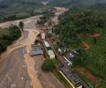
The deadly landslides in Kerala's ecologically fragile Wayanad district were triggered by a heavy burst of rainfall, made 10 per cent heavier by climate change, according to a new rapid attribution study by a global team of scientists.

A red alert has been sounded in three districts of Idukki, Thrissur and Palakkad in Kerala.
Kerala has been receiving rainfall since Saturday and 10 out of the 14 weather monitoring stations in the state have received more than 2.5 mm rains.

The IMD said that there has been an increase in the rainfall activity in Kerala and monsoon could hit the state anytime now.

The era where nations thrived through rigid alignments is giving way to an age where the connective State defines power. For India, that era has arrived, points out Dr Nishakant Ojha.

Mumbai, its satellite cities, north and central Maharashtra and south Gujarat received rains on Wednesday owing to a low-pressure area in the Arabian Sea and a western disturbance, the India meteorological department said.

A 22-year-old youth and a person with disability died, while at least 11 were injured, in separate rain-related incidents in the national capital on Wednesday evening. The incidents occurred amid sudden changes in weather in Delhi, as a rainy storm marked by hail wrecked havoc across the city, throwing traffic out of gear as far as Delhi-Noida, Delhi-Ghaziabad, and Delhi-Gurugram roads and uprooting several trees.

The India Meteorological Department (IMD) on Monday issued a warning of significant rainfall in Kerala due to cyclone Fengal, currently positioned as a strong low-pressure area over northern Tamil Nadu.

Heavy rains continue to lash parts of Kerala on Monday affecting Thiruvananthapuram, Kollam and Kottayam districts the most resulting in death of three people and widespread damage to property.

A cyclonic circulation lies over the southeast Bay of Bengal and the adjoining south Andaman Sea extending up to middle tropospheric levels. Under its influence, a low pressure area is very likely to form over the southeast Bay of Bengal and neighbourhood during the next 24 hours.

Southwest monsoon hit Kerala on Friday marking the start of the rainy season, four days after its normal onset date.
In the months immediately following the 2024 tragedy, reporting on the landslide per se had been a straightforward affair. On one side was death and destruction. On the other side, survivors and the business of survival. It was black and white. What direction to take was clear. Rehabilitation in comparison, felt like a complex situation. One that is fraught with shades of grey. As grey as human life, explains Shyam G Menon.

The IMD, in its onset date forecast on May 15, had said the monsoon is likely to hit the southern state on June 5, four days after its normal arrival.

Villpuram district in north Tamil Nadu continued to reel under unprecedented flooding on Monday following extremely heavy rainfall, virtually blocking access to villages and residential colonies as bridges and roads overflowed, inundating huge acreage of standing crops and leaving passengers stranded as rail and road traffic was hit.

People in Mumbai and Gujarat on Wednesday woke up to a dusty morning, which has now been attributed to a giant dust plume that stretched across the Arabian Sea from the coast of Oman to India.

Weather scientists attribute the early onset of southwest monsoon over Kerala to the influence of the remnants of cyclone Asani that triggered the cross-equatorial flow, a key factor for the seasonal rains.

The depression formed over Lakshadweep in the Arabian Sea would turn into a cyclonic storm in the next 24 hours and reach near the Gujarat coast on the morning of May 18, officials said.

Mumbai and certain adjoining areas experienced pre-monsoon showers, sources said on Sunday.
The weather office in Mumbai has sounded a cyclone alert for the coastal regions of south Gujarat and north Maharashtra, where it is expected to make a landfall in the early hours of Thursday.

According to IMD, the cyclonic storm weakened into a 'deep depression' at 11:30 pm on Friday over Southeast Pakistan.

For the first time in three decades, Nungambakkam, a core city area recorded 8 cmin a single day and suburban Red Hills 13 cm followed by 12 cm in Perambur, also in the city.

The Army, the National Disaster Response Force, police and the fire force along with the locals began rescue operations on Sunday morning at Koottickal and Kokkayar panchayats where over a dozen people are listed to be missing due to numerous landslides accompanied by heavy downpour since Saturday.

The Centre on Monday reviewed the preparedness of relief and rescue measures taken by Gujarat and offered help to the state in the wake of impending cyclonic storm Nilofar, which will make its landfall on Friday.

Rain or thundershowers have also been predicted in south interior Karnataka and at a few places over Coastal Karnataka and North interior Karnataka.

The cyclone would bring light to moderate rains at most places and 'heavy to very heavy downpour' at some places on November 6.